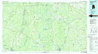
1986 Map of Monroeville
USGS Topo · Published 1986About this map
The Alabama River and Tombigbee River define the interior of this Alabama Black Belt and Piney Woods landscape, which was mapped in the mid-1980s. The regional seat at Monroeville serves as a hub for a network of rural communities, including the historic stagecoach stop at Burnt Corn and the river-bluff landing of Claiborne. Industrial and transport patterns are evident in the corridors of the Southern and Seaboard railroads, which supported the timber and agricultural economy of Wilcox, Clarke, and Monroe counties.
Find a feature on this map
164 named features on this map. Tap any name to fly to it.
Don’t see what you’re looking for? This feature index may not catch every label — zoom into the map to look around manually.
Map Details
Editions of this 1986 Monroeville Map
2 editions found
Other maps of this area

1943 · Choctaw Bluff
USGS Topo · 1:62,500

1943 · McIntosh
USGS Topo · 1:62,500

1944 · McIntosh
USGS Topo · 1:62,500

1946 · Choctaw Bluff
USGS Topo · 1:62,500

1953 · Montgomery
USGS Topo · 1:250,000

1953 · Andalusia
USGS Topo · 1:250,000

1953 · Hattiesburg
USGS Topo · 1:250,000

1953 · Meridian
USGS Topo · 1:250,000

1956 · Montgomery
USGS Topo · 1:250,000

1957 · Meridian
USGS Topo · 1:250,000