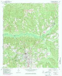
1972 Map of Monroeville
USGS Topo · Published 1986About this map
Monroeville serves as the focal point of this 1970s survey, showing the town's expansion and industrial infrastructure shortly before its mid-1980s updates. The landscape is defined by the winding course of Limestone Creek and the intersection of two major rail lines: the Burlington Northern and the Seaboard system. Local life is documented through scattered rural landmarks like Antioch Ch, Union Sch, and the Hope Hill Ch north of Peterman.
Find a feature on this map
27 named features on this map. Tap any name to fly to it.
Don’t see what you’re looking for? This feature index may not catch every label — zoom into the map to look around manually.
Map Details
Editions of this 1972 Monroeville Map
2 editions found
Other maps of this area

1953 · Andalusia
USGS Topo · 1:250,000

1957 · Andalusia
USGS Topo · 1:250,000

1967 · Beatrice
USGS Topo · 1:24,000

1971 · Burnt Corn
USGS Topo · 1:24,000

1971 · Repton
USGS Topo · 1:24,000

1971 · Beatrice
USGS Topo · 1:24,000

1972 · Monroeville
USGS Topo · 1:24,000

1972 · Frisco City
USGS Topo · 1:24,000

1972 · Natchez
USGS Topo · 1:24,000

1972 · Franklin
USGS Topo · 1:24,000