
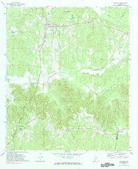
1971 Map of Beatrice
USGS Topo · Published 1974About this map
Beatrice and its surrounding countryside in Monroe County are defined by a network of rural settlements and the critical north-south corridor of the Louisville and Nashville railroad. During the early 1970s, this area of southern Alabama maintained a traditional agricultural and timber-based landscape, where small communities like Tunnel Springs and Pine Orchard anchored local life. The map details the educational and spiritual infrastructure of the era, from the Greer Jr High Sch to local landmarks like Antioch Ch. Topography is heavily influenced by the drainage basins of Flat Creek, Robinson Creek, and Brushy Creek, which carve through the terrain as they flow toward the county border with Conecuh County. The distribution of farmsteads and field lines across the uplands near Pineville and Turnbull provides a clear view of land use patterns before modern consolidated farming changed the rural character.
Find a feature on this map
16 named features on this map. Tap any name to fly to it.
Don’t see what you’re looking for? This feature index may not catch every label — zoom into the map to look around manually.
Map Details
Editions of this 1971 Beatrice Map
2 editions found
Other maps of this area

1953 · Andalusia
USGS Topo · 1:250,000

1957 · Andalusia
USGS Topo · 1:250,000

1967 · Beatrice
USGS Topo · 1:24,000

1971 · Skinnerton
USGS Topo · 1:24,000

1971 · China
USGS Topo · 1:24,000

1971 · Burnt Corn
USGS Topo · 1:24,000

1972 · Monroeville
USGS Topo · 1:24,000

1972 · Natchez
USGS Topo · 1:24,000

1973 · Vredenburgh
USGS Topo · 1:24,000
1981 · Nadawah
USGS Topo · 1:24,000