
1973 Map of Vredenburgh
USGS Topo · Published 1977About this map
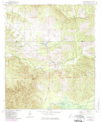
The timber and rail town of Vredenburgh sits at the heart of this early 1970s landscape, straddling the line between Wilcox and Monroe counties. This era reveals a region defined by its industrial transit, where the Louisville And Nashville and ST Louis-San Francisco railroads converge. A small Landing Strip north of town further illustrates the local infrastructure supporting the area's commerce.
Find a feature on this map
23 named features on this map. Tap any name to fly to it.
Don’t see what you’re looking for? This feature index may not catch every label — zoom into the map to look around manually.
Map Details
Editions of this 1973 Vredenburgh Map
2 editions found
Other maps of this area

1953 · Andalusia
USGS Topo · 1:250,000

1957 · Andalusia
USGS Topo · 1:250,000

1967 · Beatrice
USGS Topo · 1:24,000

1971 · Beatrice
USGS Topo · 1:24,000

1972 · Natchez
USGS Topo · 1:24,000

1972 · Franklin
USGS Topo · 1:24,000

1973 · Coy
USGS Topo · 1:24,000

1973 · Hybart
USGS Topo · 1:24,000

1973 · Camden South
USGS Topo · 1:24,000
1981 · Rosebud
USGS Topo · 1:24,000