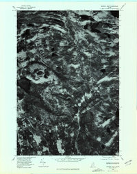
1977 Map of Monson East
USGS Topo · Published 1981About this map
Monson and the surrounding Piscataquis County landscape are captured in this orthophotoquad, which uses rectified aerial imagery to show the region exactly as it appeared in the late 1970s. The settlement pattern is clearly visible along the southern reaches, concentrated at Goodell Corner and the community center of Monson. These residential and agricultural clearings provide a sharp contrast to the dense timberland that dominates the northern half of the sheet. The hydrological network is the defining natural feature, with the sizable Big Greenwood Pond and Monson Pond anchoring the terrain. Flowing through the center of the quadrangle, Big Wilson Stream passes by Willimantic, illustrating the historical reliance on water systems for both transport and early industry in the Maine interior. The inclusion of Finn Hall provides a specific point of interest for those researching local social history and immigrant heritage in the area.
Find a feature on this map
7 named features on this map. Tap any name to fly to it.
Don’t see what you’re looking for? This feature index may not catch every label — zoom into the map to look around manually.
Map Details
Editions of this 1977 Monson East Map
This is the sole edition of this map. No revisions or reprints were ever made.
Other maps of this area

1933 · Guilford
USGS Topo · 1:62,500

1937 · Guilford
USGS Topo · 1:62,500

1948 · Kingsbury
USGS Topo · 1:62,500

1950 · Kingsbury
USGS Topo · 1:62,500

1950 · Sebec Lake
USGS Topo · 1:62,500

1951 · Greenville
USGS Topo · 1:62,500

1954 · Millinocket
USGS Topo · 1:250,000

1958 · Millinocket
USGS Topo · 1:250,000

1960 · Millinocket
USGS Topo · 1:250,000

1975 · Kingsbury NE
USGS Topo · 1:24,000