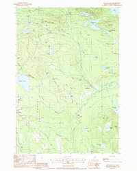
1988 Map of Monson East
USGS Topo · Published 1988About this map
Monson serves as a primary hub for this Piscataquis County landscape, where the local economy and geography are deeply intertwined with the slate industry. The survey details several industrial sites, including the Rineo Quarry, Eighteen Quarry, and Farm Quarry No 1, which underscore the region's history of mineral extraction. These quarries are often associated with local water bodies, such as Eighteen Quarry Pond, reflecting the transformation of the terrain through mining. The land is defined by a dense network of ponds and bogs, including Juniper Knee Pond and Gilman Swamp, which feed into major waterways like the Big Wilson Stream.
Find a feature on this map
68 named features on this map. Tap any name to fly to it.
Don’t see what you’re looking for? This feature index may not catch every label — zoom into the map to look around manually.
Map Details
Editions of this 1988 Monson East Map
This is the sole edition of this map. No revisions or reprints were ever made.
Other maps of this area

1933 · Guilford
USGS Topo · 1:62,500

1937 · Guilford
USGS Topo · 1:62,500

1948 · Kingsbury
USGS Topo · 1:62,500

1950 · Kingsbury
USGS Topo · 1:62,500

1950 · Sebec Lake
USGS Topo · 1:62,500

1951 · Greenville
USGS Topo · 1:62,500

1954 · Millinocket
USGS Topo · 1:250,000

1958 · Millinocket
USGS Topo · 1:250,000

1960 · Millinocket
USGS Topo · 1:250,000

1975 · Kingsbury NE
USGS Topo · 1:24,000