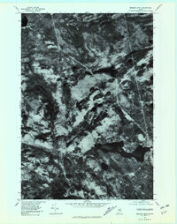
1977 Map of Monson West
USGS Topo · Published 1981About this map
Lake Hebron and the surrounding woodlands of Piscataquis County are captured in this late-1970s orthophoto, where the dense Maine forest is interrupted by the clearings of small rural settlements. The imagery highlights the localized development at Shirley Mills and Lower Shirley Corner in the northwest, contrasting with the more concentrated village of Monson situated at the eastern edge of the lake.
Find a feature on this map
9 named features on this map. Tap any name to fly to it.
Don’t see what you’re looking for? This feature index may not catch every label — zoom into the map to look around manually.
Map Details
Editions of this 1977 Monson West Map
This is the sole edition of this map. No revisions or reprints were ever made.
Other maps of this area

1933 · Guilford
USGS Topo · 1:62,500

1937 · Guilford
USGS Topo · 1:62,500

1948 · Kingsbury
USGS Topo · 1:62,500

1950 · Kingsbury
USGS Topo · 1:62,500

1950 · Sebec Lake
USGS Topo · 1:62,500

1951 · Greenville
USGS Topo · 1:62,500

1954 · Millinocket
USGS Topo · 1:250,000

1958 · Millinocket
USGS Topo · 1:250,000

1960 · Millinocket
USGS Topo · 1:250,000

1975 · Kingsbury NE
USGS Topo · 1:24,000