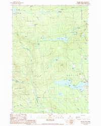
1989 Map of Monson West
USGS Topo · Published 1989About this map
Lake Hebron dominates the southern landscape of this 1980s Piscataquis County study, with the settlement of Monson positioned along its eastern shore. The terrain is characterized by a dense network of water bodies and streams, including the West Branch Piscataquis River and Spectacle Ponds. The presence of small settlements like Blanchard and Shirley Mills reflects the region's historic ties to the timber and milling industries, while Upper Shirley Corner and Lower Shirley Corner mark early crossroads in the northern section.
Find a feature on this map
51 named features on this map. Tap any name to fly to it.
Don’t see what you’re looking for? This feature index may not catch every label — zoom into the map to look around manually.
Map Details
Editions of this 1989 Monson West Map
This is the sole edition of this map. No revisions or reprints were ever made.
Other maps of this area

1933 · Guilford
USGS Topo · 1:62,500

1937 · Guilford
USGS Topo · 1:62,500

1948 · Kingsbury
USGS Topo · 1:62,500

1950 · Kingsbury
USGS Topo · 1:62,500

1950 · Sebec Lake
USGS Topo · 1:62,500

1951 · Greenville
USGS Topo · 1:62,500

1954 · Millinocket
USGS Topo · 1:250,000

1958 · Millinocket
USGS Topo · 1:250,000

1960 · Millinocket
USGS Topo · 1:250,000

1975 · Kingsbury NE
USGS Topo · 1:24,000