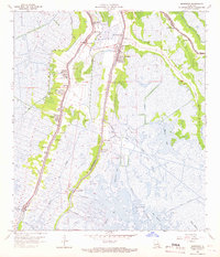
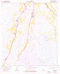
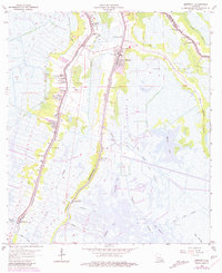
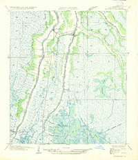
1963 Map of Montegut
USGS Topo · Published 1966About this map
Bayou Terrebonne and Bayou Petit Caillou define the settlement patterns of this coastal landscape, where narrow strips of habitable land follow the natural levees of the watercourses. Established communities like Montegut and Chauvin are concentrated along these ridges, supported by a network of drainage structures including the Boudreaux Canal and New Canal. The map documents a transition from the agricultural heritage of Sarah Plantation to the industrial presence of the Montegut Oil and Gas Field and Lirette Oil and Gas Field. Religious and educational life is well-marked by local landmarks such as Sacred Heart Ch, Mt Calvary Ch, and La Cache Jr High Sch, while the surrounding wetlands are crisscrossed by smaller waterways like Bayou Billy Goat and Bayou Pointe au Chien.
Find a feature on this map
39 named features on this map. Tap any name to fly to it.
Don’t see what you’re looking for? This feature index may not catch every label — zoom into the map to look around manually.
Map Details
Editions of this 1963 Montegut Map
3 editions found
Other maps of this area

1892 · Cut-Off
USGS Topo · 1:62,500

1892 · Houma
USGS Topo · 1:62,500

1894 · Lake Felicity
USGS Topo · 1:62,500

1894 · Dulac
USGS Topo · 1:62,500

1932 · Houma SE
USGS Topo · 1:31,680

1932 · Houma SW
USGS Topo · 1:31,680

1935 · Bourbeux
USGS Topo · 1:31,680

1935 · Viguerie Canal
USGS Topo · 1:31,680
1935 · Montegut
USGS Topo · 1:31,680

1935 · Lake Quitman
USGS Topo · 1:31,680