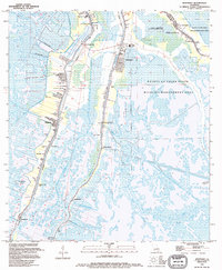
1994 Map of Montegut
USGS Topo · Published 1994About this map
Petit Caillou Bayou and Chauvin Bayou define the settlement patterns of this coastal landscape in the mid-1990s, where linear development clings to narrow ridges above the surrounding wetlands. In the community of Montegut, the Montegut Middle Sch and local cemeteries like Fire Sta Cem sit just west of the Pointe au Chien State Wildlife Management Area. To the west, the town of Chauvin is densely packed with local landmarks including Chauvin Park, St Joseph Ch, and Little Caillou Sch.
Find a feature on this map
53 named features on this map. Tap any name to fly to it.
Don’t see what you’re looking for? This feature index may not catch every label — zoom into the map to look around manually.
Map Details
Editions of this 1994 Montegut Map
This is the sole edition of this map. No revisions or reprints were ever made.
Other maps of this area

1892 · Cut-Off
USGS Topo · 1:62,500

1892 · Houma
USGS Topo · 1:62,500

1894 · Lake Felicity
USGS Topo · 1:62,500

1894 · Dulac
USGS Topo · 1:62,500

1932 · Houma SE
USGS Topo · 1:31,680

1932 · Houma SW
USGS Topo · 1:31,680

1935 · Bourbeux
USGS Topo · 1:31,680

1935 · Viguerie Canal
USGS Topo · 1:31,680

1935 · Montegut
USGS Topo · 1:31,680

1935 · Lake Quitman
USGS Topo · 1:31,680