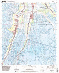
1998 Map of Montegut
USGS Topo · Published 2000About this map
Bayou Terrebonne and Bayou Petit Caillou anchor the settlement patterns of this coastal landscape, where narrow strips of habitable land follow the natural levees. Communities like Montegut and Chauvin are densely packed along these waterways, reflecting a deep reliance on the bayous for transportation and resources. The presence of Sarah Plantation and numerous local landmarks such as the Toussaint Foret Bridge and Smith Ridge Bridge highlight the historical infrastructure necessary to navigate the marshy terrain.
Find a feature on this map
57 named features on this map. Tap any name to fly to it.
Don’t see what you’re looking for? This feature index may not catch every label — zoom into the map to look around manually.
Map Details
Editions of this 1998 Montegut Map
This is the sole edition of this map. No revisions or reprints were ever made.
Other maps of this area

1892 · Cut-Off
USGS Topo · 1:62,500

1892 · Houma
USGS Topo · 1:62,500

1894 · Lake Felicity
USGS Topo · 1:62,500

1894 · Dulac
USGS Topo · 1:62,500

1932 · Houma SE
USGS Topo · 1:31,680

1932 · Houma SW
USGS Topo · 1:31,680

1935 · Bourbeux
USGS Topo · 1:31,680

1935 · Viguerie Canal
USGS Topo · 1:31,680

1935 · Montegut
USGS Topo · 1:31,680

1935 · Lake Quitman
USGS Topo · 1:31,680