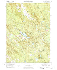
1973 Map of Monterey
USGS Topo · Published 1974About this map
Lake Garfield sits at the heart of this Berkshire County landscape, where the town of Monterey serves as a central hub for the surrounding highlands. The 1973 survey reveals a region defined by extensive conservation and education, evidenced by the large tracts of Beartown State Forest and Otis State Forest. Cultural and religious institutions are well-marked, including Hephzibah Heights, New England Keswick, and the Our Lady of the Hills Chapel. For those interested in regional history, the map preserves the location of the Old Center Cem and several summer camps like Camp Meadowlark. The Appalachian Trail winds across the ridgelines of Long Mountain, connecting remote peaks like Hunger Mtn and Sky Hill to the valley floors.
Find a feature on this map
91 named features on this map. Tap any name to fly to it.
Don’t see what you’re looking for? This feature index may not catch every label — zoom into the map to look around manually.
Map Details
Editions of this 1973 Monterey Map
3 editions found

Other maps of this area

1885 · Sheffield
USGS Topo · 1:62,500

1886 · Becket
USGS Topo · 1:62,500

1888 · Sheffield
USGS Topo · 1:62,500

1888 · Becket
USGS Topo · 1:62,500

1888 · Sandisfield
USGS Topo · 1:62,500

1888 · Pittsfield
USGS Topo · 1:62,500

1890 · Pittsfield
USGS Topo · 1:62,500

1891 · Sheffield
USGS Topo · 1:62,500

1893 · Becket
USGS Topo · 1:62,500

1893 · Sheffield
USGS Topo · 1:62,500