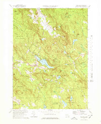
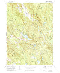
1973 Map of Monterey
USGS Topo · Published 1978About this map
The Tyringham Valley and the central village of Monterey anchor this mid-century look at the southern Berkshires, where the landscape is defined by extensive public lands like the Beartown State Forest. The Appalachian Trail winds through the northern hills, passing near Shaker Pond and over Cobble Hill, reflecting the region’s long-standing character as a destination for recreation and spiritual retreat. This is evident in the presence of Hephzibah Heights, New England Keswick, and Camp Meadowlark. Water shapes the settlement pattern here, with large bodies like Lake Garfield and Hayes Pond providing focal points for local development. Farther south, the terrain becomes more isolated, characterized by the Sandisfield State Forest and family-named landmarks such as Palmer Pond and Stedman Pond.
Find a feature on this map
78 named features on this map. Tap any name to fly to it.
Don’t see what you’re looking for? This feature index may not catch every label — zoom into the map to look around manually.
Map Details
Editions of this 1973 Monterey Map
3 editions found

Other maps of this area

1885 · Sheffield
USGS Topo · 1:62,500

1886 · Becket
USGS Topo · 1:62,500

1888 · Sheffield
USGS Topo · 1:62,500

1888 · Becket
USGS Topo · 1:62,500

1888 · Sandisfield
USGS Topo · 1:62,500

1888 · Pittsfield
USGS Topo · 1:62,500

1890 · Pittsfield
USGS Topo · 1:62,500

1891 · Sheffield
USGS Topo · 1:62,500

1893 · Becket
USGS Topo · 1:62,500

1893 · Sheffield
USGS Topo · 1:62,500