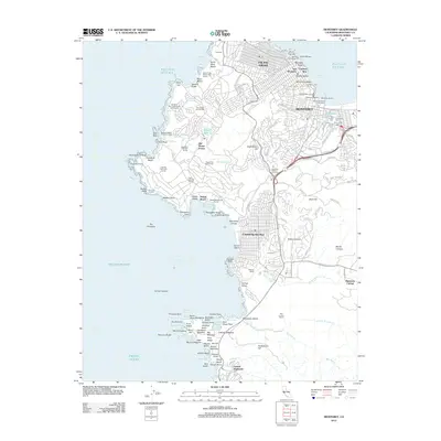
2012 Map of Monterey
USGS Topo · Published 2012About this map
Monterey and its historic waterfront define the northeastern coastline of this peninsula study, where the industrial legacy of Cannery Row meets active maritime hubs like Fishermans Wharf and the Coast Guard Pier. The urban layout transitions from the dense grids of Pacific Grove to the winding residential ways of Del Monte Forest and Carmel-by-the-Sea. Inland, the landscape is marked by diverse topography ranging from Huckleberry Hill to the banks of the Carmel River. Genealogists will find significant detail in the cluster of burial grounds near El Estero, including San Carlos Cem and Saint Johns Cem. Along the southern coast, the map documents the intricate rocky shoreline of the Point Lobos area, featuring landmarks such as Whalers Cove and China Cove, while the interior shows the developed footprint of the California Division of Forestry and various golf courses including The Links at Spanish Bay.
Find a feature on this map
143 named features on this map. Tap any name to fly to it.
Don’t see what you’re looking for? This feature index may not catch every label — zoom into the map to look around manually.
Map Details
Editions of this 2012 Monterey Map
This is the sole edition of this map. No revisions or reprints were ever made.
Other maps of this area

1913 · Monterey
USGS Topo · 1:62,500

1918 · Point Sur
USGS Topo · 1:62,500

1925 · Point Sur
USGS Topo · 1:62,500

1941 · Monterey
USGS Topo · 1:62,500

1947 · Point Sur
USGS Topo · 1:62,500

1947 · Seaside
USGS Topo · 1:24,000

1947 · Monterey
USGS Topo · 1:62,500
1947 · Marina
USGS Topo · 1:24,000

1947 · Monterey
USGS Topo · 1:24,000

1948 · Santa Cruz
USGS Topo · 1:250,000
Featured Places
- Monterey, CA
- Pacific Grove, CA
- Carmel-by-the-Sea, CA
- Carmel Highlands, CA
- Pebble Beach, Del Monte Forest