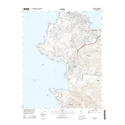
2015 Map of Monterey
USGS Topo · Published 2015About this map
The Monterey Peninsula shoreline dominates this 2015 study, documenting the dense urban grid and rugged coastal points from Pacific Grove down to the Carmel Highlands. The map illustrates the region's concentration of educational and military institutions, including the Defense Language Institute and the Monterey Institute of International Studies. Moving south, the terrain transitions into the iconic landscapes of Pebble Beach and the artistic enclave of Carmel-by-the-Sea. Inland, the relief of Huckleberry Hill and the Santa Lucia Range provides a contrast to the Pacific frontage. For those researching local development, the survey captures the established residential patterns of New Monterey and the industrial heritage surrounding Cannery Row, alongside preserved spaces like El Encinal Cemetery and the protected waters of Carmel Bay.
Find a feature on this map
279 named features on this map. Tap any name to fly to it.
Don’t see what you’re looking for? This feature index may not catch every label — zoom into the map to look around manually.
Map Details
Editions of this 2015 Monterey Map
This is the sole edition of this map. No revisions or reprints were ever made.
Other maps of this area

1913 · Monterey
USGS Topo · 1:62,500

1918 · Point Sur
USGS Topo · 1:62,500

1925 · Point Sur
USGS Topo · 1:62,500

1941 · Monterey
USGS Topo · 1:62,500

1947 · Point Sur
USGS Topo · 1:62,500

1947 · Seaside
USGS Topo · 1:24,000

1947 · Monterey
USGS Topo · 1:62,500
1947 · Marina
USGS Topo · 1:24,000

1947 · Monterey
USGS Topo · 1:24,000

1948 · Santa Cruz
USGS Topo · 1:250,000
Featured Places
- Monterey, CA
- Pacific Grove, CA
- Carmel-by-the-Sea, CA
- Carmel Highlands, CA
- Pebble Beach, Del Monte Forest