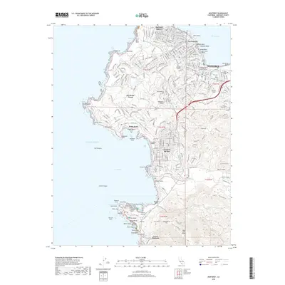
2018 Map of Monterey
USGS Topo · Published 2018About this map
Monterey and its neighboring coastal communities are meticulously detailed in this 2018 survey, which shows the dense urban grid of Pacific Grove and the winding scenic corridors of Del Monte Forest. The map documents the historic industrial stretch of Cannery Row and the adjacent military and educational institutions like the Naval Postgraduate School and Defense Language Institute. To the south, the topography shifts from the developed coastline of Carmel-by-the-Sea to the dramatic headlands of Point Lobos.
Find a feature on this map
95 named features on this map. Tap any name to fly to it.
Don’t see what you’re looking for? This feature index may not catch every label — zoom into the map to look around manually.
Map Details
Editions of this 2018 Monterey Map
This is the sole edition of this map. No revisions or reprints were ever made.
Other maps of this area

1913 · Monterey
USGS Topo · 1:62,500

1918 · Point Sur
USGS Topo · 1:62,500

1925 · Point Sur
USGS Topo · 1:62,500

1941 · Monterey
USGS Topo · 1:62,500

1947 · Point Sur
USGS Topo · 1:62,500

1947 · Seaside
USGS Topo · 1:24,000

1947 · Monterey
USGS Topo · 1:62,500
1947 · Marina
USGS Topo · 1:24,000

1947 · Monterey
USGS Topo · 1:24,000

1948 · Santa Cruz
USGS Topo · 1:250,000
Featured Places
- Monterey, CA
- Pacific Grove, CA
- Carmel-by-the-Sea, CA
- Carmel Highlands, CA
- Pebble Beach, Del Monte Forest