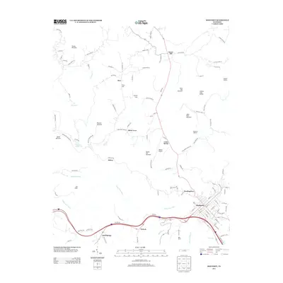
2013 Map of Monterey
USGS Topo · Published 2013About this map
Monterey sits at the heart of this East Tennessee landscape, where the grid of the town center transitions into the winding mountain roads of Putnam County. The terrain is defined by a series of prominent peaks and deep hollows, including Turkey Mountain in the north and the jagged heights of Table Rock Mountain and Bee Rock to the south. Historically significant named settlements like Shady Grove, Sand Springs, and Standingstone are linked by a network of rural routes such as Stamps Shady Grove Rd and Wilmoth Rd, illustrating the dispersed residential patterns of the Cumberland Plateau. Water features like the Falling Water River and its tributaries, including Whittaker Br and Stamps Hollow Cr, carve through the landscape, providing a natural framework for the region's topography and small lakeside communities like Gordan Hunter Lake.
Find a feature on this map
113 named features on this map. Tap any name to fly to it.
Don’t see what you’re looking for? This feature index may not catch every label — zoom into the map to look around manually.
Map Details
Editions of this 2013 Monterey Map
This is the sole edition of this map. No revisions or reprints were ever made.
Other maps of this area

1897 · Standingstone
USGS Topo · 1:125,000

1898 · Standingstone
USGS Topo · 1:125,000

1935 · Campbell Junction
USGS Topo · 1:24,000

1943 · Cookeville
USGS Topo · 1:100,000

1944 · Cookeville
USGS Topo · 1:100,000

1946 · Campbell Junction
USGS Topo · 1:24,000

1946 · Obey City
USGS Topo · 1:24,000
1950 · Obey City
USGS Topo · 1:24,000
1950 · Campbell Junction
USGS Topo · 1:24,000

1951 · Windle
USGS Topo · 1:24,000