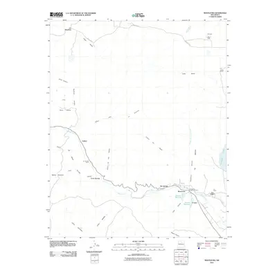
2010 Map of Montezuma
USGS Topo · Published 2010About this map
Gallinas Creek winds through this New Mexico landscape, carving a path toward the settlement of Montezuma and the nearby Hot Springs. The area's topography is defined by sharp elevation changes, most notably along The Creston, a prominent ridge that separates the western canyons from the eastern basin. Water management is a central theme of this 2010 survey, with infrastructure like the Peterson Reservoir, Bradner Reservoir, and the significant expanse of Storrie Lake supporting the local ranches and communities.
Find a feature on this map
40 named features on this map. Tap any name to fly to it.
Don’t see what you’re looking for? This feature index may not catch every label — zoom into the map to look around manually.
Map Details
Editions of this 2010 Montezuma Map
This is the sole edition of this map. No revisions or reprints were ever made.
Other maps of this area

1889 · Las Vegas
USGS Topo · 1:125,000

1891 · Las Vegas
USGS Topo · 1:125,000

1893 · Las Vegas
USGS Topo · 1:125,000

1954 · Santa Fe
USGS Topo · 1:250,000

1958 · Santa Fe
USGS Topo · 1:250,000

1961 · San Geronimo
USGS Topo · 1:24,000

1961 · El Porvenir
USGS Topo · 1:24,000

1961 · Montezuma
USGS Topo · 1:24,000
1961 · Ojitos Frios
USGS Topo · 1:24,000

1963 · Lake Isabel
USGS Topo · 1:24,000