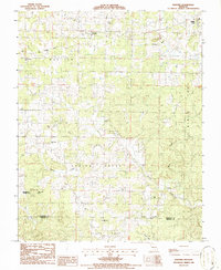
1986 Map of Montier
USGS Topo · Published 1986About this map
Montier and Birch Tree anchor the northern landscape of this mid-1980s Missouri Ozarks survey, where the terrestrial economy is defined by its industrial history and religious centers. Scattered throughout the townships are community landmarks such as Pleasant Grove Ch, Mt Calvary Ch, and Bethlehem Ch, illustrating the local social structure of Shannon Co and Oregon Co. The transport network shows a significant transition, dominated by the Old Railroad Grade cutting across the northern half of the map, a remnant of former timber or freight routes. Traces of extractive industry are visible at the Abd Mine and its associated Abd Tailings Pond, while the southern reaches are marked by the rugged drainage of Spring Creek and the Thomasville Tower Site atop High Hill.
Find a feature on this map
21 named features on this map. Tap any name to fly to it.
Don’t see what you’re looking for? This feature index may not catch every label — zoom into the map to look around manually.
Map Details
Editions of this 1986 Montier Map
This is the sole edition of this map. No revisions or reprints were ever made.
Other maps of this area

1915 · Eminence
USGS Topo · 1:62,500

1917 · Eminence
USGS Topo · 1:62,500

1931 · Bandyville
USGS Topo · 1:48,000

1944 · Birch Tree
USGS Topo · 1:62,500

1945 · Montier
USGS Topo · 1:62,500

1946 · Summersville
USGS Topo · 1:62,500

1948 · Montier
USGS Topo · 1:62,500

1948 · Birch Tree
USGS Topo · 1:62,500

1948 · Summersville
USGS Topo · 1:62,500

1949 · Rolla
USGS Topo · 1:250,000