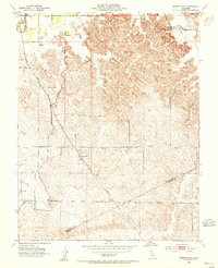
1953 Map of Montpelier
USGS Topo · Published 1955About this map
Agricultural development and water management define the landscape of eastern Stanislaus County in this mid-century survey. The community of Montpelier serves as a local hub for the region's ranching and grain economy, anchored by a prominent Grain Elevator and a Water Tank along the Southern Pacific rail line. To the northwest, the settlement of Hickman sits near the crossing of the La Grange Main Canal, reflecting the complex irrigation infrastructure necessary for Central Valley farming. The map traces the intricate paths of the Turlock Main Canal and Monte Vista Canal, which snake through the undulating terrain. A network of rural roads, including Montpelier Road, Whitmore Ave, and La Grange Road, connects these scattered homesteads and windmills, marking the border where the county line meets Merced County.
Find a feature on this map
25 named features on this map. Tap any name to fly to it.
Don’t see what you’re looking for? This feature index may not catch every label — zoom into the map to look around manually.
Map Details
Editions of this 1953 Montpelier Map
This is the sole edition of this map. No revisions or reprints were ever made.
Other maps of this area

1913 · Dickenson
USGS Topo · 1:31,680

1915 · Paulsell
USGS Topo · 1:31,680

1916 · Three Tree Flat
USGS Topo · 1:31,680

1916 · Cressey
USGS Topo · 1:31,680

1916 · Montpellier
USGS Topo · 1:31,680

1916 · Cooperstown
USGS Topo · 1:31,680

1916 · Denair
USGS Topo · 1:31,680

1916 · Waterford
USGS Topo · 1:31,680

1917 · Turlock
USGS Topo · 1:31,680

1917 · Winton
USGS Topo · 1:31,680