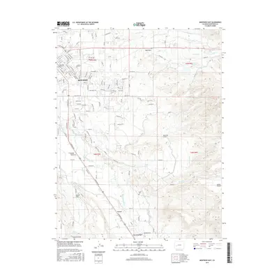
2016 Map of Montrose East
USGS Topo · Published 2016About this map
The Uncompahgre River valley serves as the central artery for this Western Slope landscape, where the city of Montrose expands eastward into a complex network of agricultural irrigation. The map documents an intricate system of water management, featuring the South Canal, Loutsenhizer Canal, and numerous laterals like the A B E-Lateral that support the surrounding fields. Local heritage is preserved in sites such as Cedar Cem and Button Cem, while the modern community is anchored by the Colorado Mesa Univ-Montrose Campus. Moving south from the city center, the terrain transitions toward Vernal and the community of Uncompahgre, bounded by the deep cuts of Duckett Draw and the beginning of Dolores Canyon. This survey captures the intersection of traditional high-desert ranching and the growth of a regional hub in the early 21st century.
Find a feature on this map
123 named features on this map. Tap any name to fly to it.
Don’t see what you’re looking for? This feature index may not catch every label — zoom into the map to look around manually.
Map Details
Editions of this 2016 Montrose East Map
This is the sole edition of this map. No revisions or reprints were ever made.
Other maps of this area

1909 · Montrose
USGS Topo · 1:125,000

1911 · Montrose
USGS Topo · 1:125,000

1955 · Olathe
USGS Topo · 1:24,000

1955 · Red Rock Canyon
USGS Topo · 1:24,000

1956 · Montrose
USGS Topo · 1:250,000

1957 · Cerro Summit
USGS Topo · 1:24,000

1957 · Grizzly Ridge
USGS Topo · 1:24,000

1959 · Montrose
USGS Topo · 1:250,000

1960 · Montrose
USGS Topo · 1:250,000
1962 · Montrose East
USGS Topo · 1:24,000