
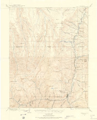
1909 Map of Montrose
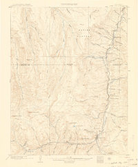
USGS Topo · Published 1960About this map
Montrose serves as the northern anchor for this regional study, which tracks the Uncompahgre River corridor south toward the high peaks. The influence of the Denver and Rio Grande Western RR is evident throughout the valley, linking settlements like Colona, Eldredge, and Ridgway. This rail-and-river network supported a diverse economy of ranching and extraction, evidenced by labels for the Sawmill in the Log Hill Mesa area and the Blaine Mine to the south.
Find a feature on this map
106 named features on this map. Tap any name to fly to it.
Don’t see what you’re looking for? This feature index may not catch every label — zoom into the map to look around manually.
Map Details
Editions of this 1909 Montrose Map
This is the sole edition of this map. No revisions or reprints were ever made.
Other maps of this area

1897 · Telluride
USGS Topo · 1:62,500

1897 · Silverton
USGS Topo · 1:62,500

1901 · Silverton
USGS Topo · 1:62,500

1902 · Silverton
USGS Topo · 1:62,500

1902 · Ouray
USGS Topo · 1:62,500
1903 · Lake City
USGS Topo · 1:62,500

1904 · Ouray
USGS Topo · 1:62,500

1904 · Telluride
USGS Topo · 1:62,500
1905 · Lake City
USGS Topo · 1:62,500

1905 · San Cristobal
USGS Topo · 1:125,000