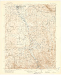
1911 Map of Montrose
USGS Topo · Published 1911About this map
The Uncompahgre River valley serves as the primary corridor for commerce and settlement in this early twentieth-century survey, with the Denver and Rio Grande RR tracing the water's edge. At the northern end of the valley, Montrose emerges as a regional hub, surrounded by agricultural efforts on Spring Mesa and in the Shavano Valley. As the elevation rises toward the southern peaks, the landscape shifts toward extractive industries and early mountain communities. The survey records infrastructure supporting this growth, including the Water Tank near West Baldy and the high-altitude Blaine Mine located under the shadow of Sneffels Peak. Significant topographic detail captures the transition from the flatlands of Howard Flats to the jagged boundaries of the Gunnison National Forest and the sheer walls of Gunnison Canyon. Small outposts like Bachelor Switch and Colona mark the progression of the rail line into the heart of the San Juan Mountains.
Find a feature on this map
92 named features on this map. Tap any name to fly to it.
Don’t see what you’re looking for? This feature index may not catch every label — zoom into the map to look around manually.
Map Details
Editions of this 1911 Montrose Map
3 editions found
Historical Maps of Montrose Through Time
7 maps found