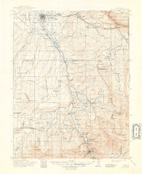
1911 Map of Montrose
USGS Topo · Published 1948About this map
Montrose and Ouray anchor this turn-of-the-century landscape, connected by the vital corridor of the Denver and Rio Grande Western Railroad. The terrain transitions from the wide expanses of Spring Creek Mesa in the north to the high-altitude peaks of the Uncompahgre National Forest in the south. Along the Uncompahgre River, small settlements and ranching hubs like Ridgway, Colona, and Thomas Ranch trace the valley floor. The map highlights the early industrial footprint of the region, from the Blaine Mine near the southern border to a Sawmill in the L O G H I L L M E S A. Remote mountain outposts such as Bachelor Switch and Dallas Divide reflect the era's reliance on rail transport to navigate the high passes of the San Juan Mountains.
Find a feature on this map
113 named features on this map. Tap any name to fly to it.
Don’t see what you’re looking for? This feature index may not catch every label — zoom into the map to look around manually.
Map Details
Editions of this 1911 Montrose Map
3 editions found

Other maps of this area

1897 · Telluride
USGS Topo · 1:62,500

1897 · Silverton
USGS Topo · 1:62,500

1901 · Silverton
USGS Topo · 1:62,500

1902 · Silverton
USGS Topo · 1:62,500

1902 · Ouray
USGS Topo · 1:62,500

1903 · Lake City
USGS Topo · 1:62,500

1904 · Ouray
USGS Topo · 1:62,500

1904 · Telluride
USGS Topo · 1:62,500

1905 · Lake City
USGS Topo · 1:62,500

1905 · San Cristobal
USGS Topo · 1:125,000