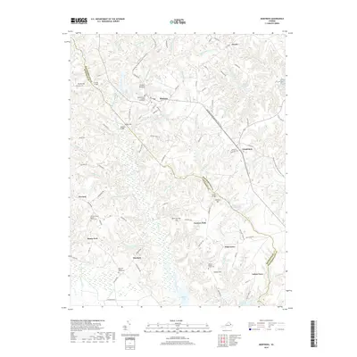
2019 Map of Montross
USGS Topo · Published 2019About this map
Montross serves as the focal point for this section of the Northern Neck, where the Westmoreland County Courthouse anchors the local civic landscape. The surrounding area is defined by a dense network of wetlands and drainages, including the expansive The Big Swamp, Black Swamp, and Grandmammy Swamp. This hydrologic pattern influenced the placement of historical mill sites, evidenced by Weavers Millpond and Omohondro Millpond. Small rural settlements like Templeman, Farmers Fork, and Zacata are connected by a web of winding roads such as Chilton Rd and Eppings Tract Rd. For those interested in the area's social history, several religious sites with associated burial grounds are documented, including Welcome Grove Baptist Church Cem and Menokin Baptist Church Cem. The map also traces a significant portion of the Potomac Heritage National Scenic Trail as it winds through the varied terrain between Pantico Hill and Rock Springs Hill.
Find a feature on this map
112 named features on this map. Tap any name to fly to it.
Don’t see what you’re looking for? This feature index may not catch every label — zoom into the map to look around manually.
Map Details
Editions of this 2019 Montross Map
This is the sole edition of this map. No revisions or reprints were ever made.
Other maps of this area

1892 · Piney Point
USGS Topo · 1:62,500

1892 · Montross
USGS Topo · 1:62,500

1894 · Piney Point
USGS Topo · 1:62,500

1895 · Nomini
USGS Topo · 1:125,000

1895 · Piney Point
USGS Topo · 1:62,500

1895 · Montross
USGS Topo · 1:62,500

1898 · Nomini
USGS Topo · 1:125,000

1901 · Piney Point
USGS Topo · 1:62,500

1917 · Morattico
USGS Topo · 1:62,500

1918 · Tappahannock
USGS Topo · 1:62,500