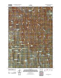
2011 Map of Monument Peak
USGS Topo · Published 2011About this map
Monument Peak rises as a primary landmark in this section of Malheur County, where the high desert landscape is defined by a complex network of seasonal drainages and stock water infrastructure. The topography is marked by expansive high-elevation features like School Section Table and Deacon Flat, alongside named basins such as Shovel Basin and Wildhorse Basin. Human presence is largely oriented around ranching and land management, indicated by the network of reservoirs including Nanny Reservoir, Pinhead Reservoir, and the sequential Dinner Creek Reservoir Number One through Three. The map shows the remote transit routes of Shumway Rd and the Monument Peak Guard Station Rd, which navigate the draws and ridges between Hunter Peak and Jones Butte. Jones Horse Camp provides a specific point of historical interest in an area otherwise dominated by the utilitarian management of water and livestock across the rugged Oregon interior.
Find a feature on this map
51 named features on this map. Tap any name to fly to it.
Don’t see what you’re looking for? This feature index may not catch every label — zoom into the map to look around manually.
Map Details
Editions of this 2011 Monument Peak Map
This is the sole edition of this map. No revisions or reprints were ever made.
Other maps of this area

1955 · Burns
USGS Topo · 1:250,000

1955 · Boise
USGS Topo · 1:250,000

1958 · Burns
USGS Topo · 1:250,000

1958 · Boise
USGS Topo · 1:250,000

1959 · Burns
USGS Topo · 1:250,000

1962 · Boise
USGS Topo · 1:250,000

1966 · Westfall Butte
USGS Topo · 1:62,500

1966 · Beulah
USGS Topo · 1:62,500

1972 · Tims Peak
USGS Topo · 1:24,000

1972 · Shumway Reservoir
USGS Topo · 1:24,000