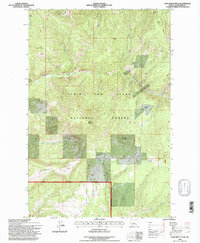
1995 Map of Monument Peak
USGS Topo · Published 1997About this map
Monument Peak Lookout stands as the literal and figurative high point of this high-altitude landscape within the Lewis and Clark National Forest. Revised in the mid-1990s, the map reveals a wilderness dominated by steep drainage systems like Tenderfoot Creek and Eagle Creek, where the terrain transitions sharply between named heights such as Mount Vesuvius and Woods Mountain. For the researcher, the map documents small-scale industrial history through several labeled prospects and a single prospect site located near the headwaters of Taylor Creek and Reynolds Creek. These markers, along with the notable Rimrock Ridge, indicate a terrain shaped by both geological survey interest and remote forest management. The presence of developed landmarks like Reynolds Park and Daisy Spring suggests established points of interest for those navigating this portion of Meagher County's mountain country.
Find a feature on this map
25 named features on this map. Tap any name to fly to it.
Don’t see what you’re looking for? This feature index may not catch every label — zoom into the map to look around manually.
Map Details
Editions of this 1995 Monument Peak Map
This is the sole edition of this map. No revisions or reprints were ever made.
Other maps of this area

1886 · Great Falls
USGS Topo · 1:250,000

1886 · Fort Logan
USGS Topo · 1:250,000

1886 · Little Belt Mts.
USGS Topo · 1:250,000

1890 · Fort Benton
USGS Topo · 1:250,000

1892 · Fort Benton
USGS Topo · 1:250,000

1894 · Little Belt Mts.
USGS Topo · 1:250,000

1897 · Fort Benton
USGS Topo · 1:250,000

1897 · Little Belt Mts.
USGS Topo · 1:250,000

1898 · Little Belt Mts.
USGS Topo · 1:250,000

1902 · Little Belt Mts.
USGS Topo · 1:250,000