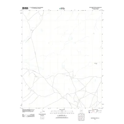
2011 Map of Monument Point
USGS Topo · Published 2011About this map
Monument Point stands as a prominent topographical landmark in this section of Coconino County, characterizing a landscape defined by drainage patterns and tribal infrastructure. Recorded by the U. S. Geological Survey in 2011, the area is interlaced with a network of local transportation routes, including Hopi Reservation Rd, which connects with Indian Rte 6720 and Indian Rte 6730. These roads trace the arid terrain where water management is visible through features like Hiway Tank. The map provides a detailed view of the contemporary geographic layout within the reservation lands, showing how modern transit corridors follow the natural contours of the Arizona plateau.
Find a feature on this map
5 named features on this map. Tap any name to fly to it.
Don’t see what you’re looking for? This feature index may not catch every label — zoom into the map to look around manually.
Map Details
Editions of this 2011 Monument Point Map
This is the sole edition of this map. No revisions or reprints were ever made.
Other maps of this area

1883 · Tusayan
USGS Topo · 1:250,000

1886 · Tusayan
USGS Topo · 1:250,000

1886 · San Francisco Mtns
USGS Topo · 1:250,000

1891 · San Francisco Mtns
USGS Topo · 1:250,000

1894 · San Francisco Mtns
USGS Topo · 1:250,000

1899 · San Francisco Mtns
USGS Topo · 1:250,000

1947 · Flagstaff
USGS Topo · 1:250,000

1954 · Flagstaff
USGS Topo · 1:250,000

1955 · Grand Falls NE
USGS Topo · 1:24,000
1955 · Black Falls 4 SE
USGS Topo · 1:24,000