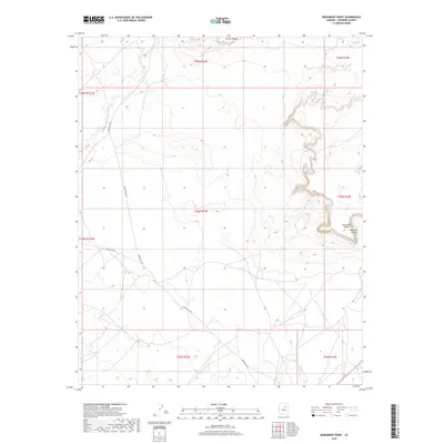
2018 Map of Monument Point
USGS Topo · Published 2018About this map
Garces Mesas dominates the northern horizon of this Coconino County terrain, where high-desert plateaus are carved by intricate drainages. The landscape is defined by the dramatic escarpments of Monument Point and the adjacent Kachina Points, features that emphasize the elevation changes characteristic of this region. Navigation through the area relies on a sparse network of service roads, primarily Indian Rte 6720 and Indian Rte 6730, which traverse the lower plains and skirt the base of the major mesas. This 2018 survey illustrates a remote landscape where the natural topography remains the primary influence on movement and land division. The detailed contour work reveals the complex erosional patterns that have shaped these landforms over millennia, providing a clear picture of the physical geography before any significant modern development.
Find a feature on this map
13 named features on this map. Tap any name to fly to it.
Don’t see what you’re looking for? This feature index may not catch every label — zoom into the map to look around manually.
Map Details
Editions of this 2018 Monument Point Map
This is the sole edition of this map. No revisions or reprints were ever made.
Other maps of this area

1883 · Tusayan
USGS Topo · 1:250,000

1886 · Tusayan
USGS Topo · 1:250,000

1886 · San Francisco Mtns
USGS Topo · 1:250,000

1891 · San Francisco Mtns
USGS Topo · 1:250,000

1894 · San Francisco Mtns
USGS Topo · 1:250,000

1899 · San Francisco Mtns
USGS Topo · 1:250,000

1947 · Flagstaff
USGS Topo · 1:250,000

1954 · Flagstaff
USGS Topo · 1:250,000

1955 · Grand Falls NE
USGS Topo · 1:24,000
1955 · Black Falls 4 SE
USGS Topo · 1:24,000