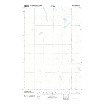
2011 Map of Moon Lake
USGS Topo · Published 2011About this map
Moon Lake and Saint Marys Lake dominate this portion of the North Dakota prairie, illustrating a landscape defined by glacial potholes and seasonal wetlands. The 2011 survey reveals a strictly organized section-line road network, where routes like 105th Ave SE and 40th St SE carve the terrain into precise agricultural blocks. This grid-heavy geography is interrupted only by the natural wandering of Spring Creek, which meanders through the southwestern quadrant. The map captures a quintessential Great Plains environment, where the sparse placement of structures and the concentration of water bodies in the northeast suggest a land primarily dedicated to large-scale farming and waterfowl habitat. For researchers, it provides a clear record of rural infrastructure and water drainage patterns before more modern intensive developments might alter these prairie potholes.
Find a feature on this map
17 named features on this map. Tap any name to fly to it.
Don’t see what you’re looking for? This feature index may not catch every label — zoom into the map to look around manually.
Map Details
Editions of this 2011 Moon Lake Map
This is the sole edition of this map. No revisions or reprints were ever made.
Other maps of this area

1897 · Eckelson
USGS Topo · 1:125,000

1953 · Jamestown
USGS Topo · 1:250,000

1956 · Jamestown
USGS Topo · 1:250,000

1961 · Valley City West
USGS Topo · 1:24,000

1970 · Litchville
USGS Topo · 1:24,000
1970 · Hastings
USGS Topo · 1:24,000

1970 · Eckelson
USGS Topo · 1:24,000
1970 · Moon Lake
USGS Topo · 1:24,000

1970 · Marion NE
USGS Topo · 1:24,000
1970 · Sanborn SE
USGS Topo · 1:24,000