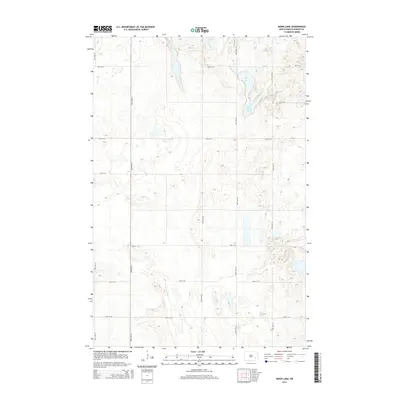
2014 Map of Moon Lake
USGS Topo · Published 2014About this map
Moon Lake and its smaller neighbor, Saint Marys Lake, define the north-central topography of this Barnes County landscape. The area is characterized by the glacial depressions typical of the North Dakota prairie, where numerous unnamed sloughs and potholes dot the grid of section-line roads. The southern portion of the quadrangle is drained by the meandering course of Spring Creek, which cuts through the agricultural sections as it flows toward the southeast.
Find a feature on this map
15 named features on this map. Tap any name to fly to it.
Don’t see what you’re looking for? This feature index may not catch every label — zoom into the map to look around manually.
Map Details
Editions of this 2014 Moon Lake Map
This is the sole edition of this map. No revisions or reprints were ever made.
Other maps of this area

1897 · Eckelson
USGS Topo · 1:125,000

1953 · Jamestown
USGS Topo · 1:250,000

1956 · Jamestown
USGS Topo · 1:250,000

1961 · Valley City West
USGS Topo · 1:24,000

1970 · Litchville
USGS Topo · 1:24,000
1970 · Hastings
USGS Topo · 1:24,000

1970 · Eckelson
USGS Topo · 1:24,000
1970 · Moon Lake
USGS Topo · 1:24,000

1970 · Marion NE
USGS Topo · 1:24,000
1970 · Sanborn SE
USGS Topo · 1:24,000