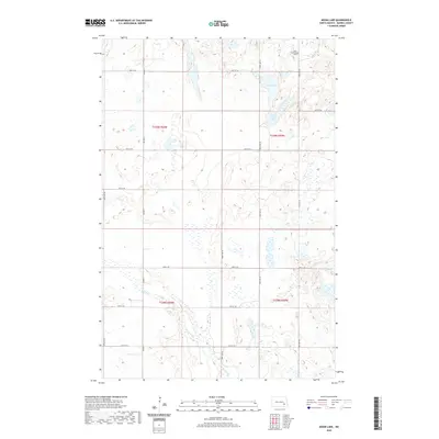
2020 Map of Moon Lake
USGS Topo · Published 2020About this map
Moon Lake and the adjacent Saint Marys Lake anchor this glaciated terrain in Skandia Township, where small prairie potholes and wetlands pattern the landscape. This 2020 survey reveals the rural character of Barnes County, defined by a rigid grid of section roads like 110th Ave SE and 40th St SE. For genealogists and local historians, the presence of the Zion Lutheran Cem in the northeast corner provides a critical point of reference for early Norwegian-American Lutheran settlement patterns. The drainage of Spring Creek (labeled in parts as Spring Cr) flows through the southern sections, cutting across the township boundaries of t138n r60w and t138n r59w. Aside from these water bodies and the cemetery, the map reflects a purely agrarian environment served by county routes like Co Hwy 11.
Find a feature on this map
22 named features on this map. Tap any name to fly to it.
Don’t see what you’re looking for? This feature index may not catch every label — zoom into the map to look around manually.
Map Details
Editions of this 2020 Moon Lake Map
This is the sole edition of this map. No revisions or reprints were ever made.
Other maps of this area

1897 · Eckelson
USGS Topo · 1:125,000

1953 · Jamestown
USGS Topo · 1:250,000

1956 · Jamestown
USGS Topo · 1:250,000

1961 · Valley City West
USGS Topo · 1:24,000

1970 · Litchville
USGS Topo · 1:24,000
1970 · Hastings
USGS Topo · 1:24,000

1970 · Eckelson
USGS Topo · 1:24,000
1970 · Moon Lake
USGS Topo · 1:24,000

1970 · Marion NE
USGS Topo · 1:24,000
1970 · Sanborn SE
USGS Topo · 1:24,000