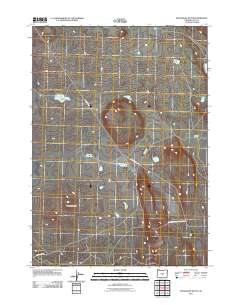
2011 Map of Moonlight Butte
USGS Topo · Published 2011About this map
Moonlight Butte and the arid eastern Oregon landscape define this high-desert region in Lake County. The map details a network of vital water sources essential for range management and wildlife, including Bull Lake Waterhole, Little Sagehen Waterhole, and Chicago Pond. These isolated features indicate the historical and contemporary reliance on seasonal water in an otherwise parched environment. The southeastern portion of the quadrangle is occupied by the Lost Forest Research Natl Area, an unusual island of ponderosa pines separated from the nearest forest by miles of sagebrush. Transportation is limited to a few arterial routes such as Lost Forest Rd and several Bureau of Land Management tracks, illustrating the sparse settlement and focus on conservation and research within the Browns Valley vicinity.
Find a feature on this map
10 named features on this map. Tap any name to fly to it.
Don’t see what you’re looking for? This feature index may not catch every label — zoom into the map to look around manually.
Map Details
Editions of this 2011 Moonlight Butte Map
This is the sole edition of this map. No revisions or reprints were ever made.
Other maps of this area

1955 · Crescent
USGS Topo · 1:250,000

1957 · Crescent
USGS Topo · 1:250,000

1958 · Crescent
USGS Topo · 1:250,000

1970 · Crescent
USGS Topo · 1:250,000

1981 · Fossil Lake
USGS Topo · 1:24,000

1981 · Sand Rock
USGS Topo · 1:24,000

1981 · Moonlight Butte
USGS Topo · 1:24,000

1981 · Mean Rock Well
USGS Topo · 1:24,000

1981 · Elk Butte
USGS Topo · 1:24,000

1981 · Chicago Valley
USGS Topo · 1:24,000