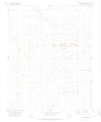
1978 Map of Moore Draw SE
USGS Topo · Published 1978About this map
Moore Draw cuts a prominent path through the high plains of southeastern Colorado in this USGS topographical study based on mid-1970s aerial photography. The landscape of Baca County is defined here by a series of intermittent drainage systems, including Mitchell Draw and Murray Draw, which carve subtle relief into the flat terrain. This map reveals a largely undeveloped expanse, where the primary human footprint is found in the scattered extractive sites such as the Gravel Pits located near the center of the quadrangle and a smaller Gravel Pit to the south. These features suggest a local economy reliant on road-building materials and basic infrastructure during this period. The absence of major settlements highlights the rural character of the region, emphasizing the importance of these natural waterways and the section-line roads that crisscross the territory.
Find a feature on this map
5 named features on this map. Tap any name to fly to it.
Don’t see what you’re looking for? This feature index may not catch every label — zoom into the map to look around manually.
Map Details
Editions of this 1978 Moore Draw SE Map
This is the sole edition of this map. No revisions or reprints were ever made.
Other maps of this area

1892 · Vilas
USGS Topo · 1:125,000

1954 · Dalhart
USGS Topo · 1:250,000

1955 · La Junta
USGS Topo · 1:250,000

1958 · La Junta
USGS Topo · 1:250,000

1958 · Dalhart
USGS Topo · 1:250,000

1962 · Dalhart
USGS Topo · 1:250,000

1968 · La Junta
USGS Topo · 1:250,000

1971 · Keyes NW
USGS Topo · 1:24,000

1971 · Keyes NE
USGS Topo · 1:24,000
1971 · Sturgis NW
USGS Topo · 1:24,000