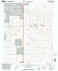
1996 Map of Moore Draw SE
USGS Topo · Published 2000About this map
Comanche National Grassland encompasses a significant portion of this high plains landscape, where the seasonal watercourses of Moore Draw and Mitchell Draw carve subtle relief into the terrain. This 1996 revision, published by the U.S. Geological Survey and USDA Forest Service, highlights the management of these public lands through features like the Wildlife Exclosure located in the southern portion of the sheet. The map reflects a landscape primarily defined by livestock grazing and conservation, with several Gravel Pits and a smaller Gravel Pit scattered across the draws, indicating local material extraction used for maintaining the network of light-duty and unimproved roads. The topography, compiled originally in the early 1970s and updated with 1990s imagery, reveals the drainage patterns essential to ranching in this corner of Baca County.
Find a feature on this map
7 named features on this map. Tap any name to fly to it.
Don’t see what you’re looking for? This feature index may not catch every label — zoom into the map to look around manually.
Map Details
Editions of this 1996 Moore Draw SE Map
This is the sole edition of this map. No revisions or reprints were ever made.
Other maps of this area

1892 · Vilas
USGS Topo · 1:125,000

1954 · Dalhart
USGS Topo · 1:250,000

1955 · La Junta
USGS Topo · 1:250,000

1958 · La Junta
USGS Topo · 1:250,000

1958 · Dalhart
USGS Topo · 1:250,000

1962 · Dalhart
USGS Topo · 1:250,000

1968 · La Junta
USGS Topo · 1:250,000

1971 · Keyes NW
USGS Topo · 1:24,000

1971 · Keyes NE
USGS Topo · 1:24,000
1971 · Sturgis NW
USGS Topo · 1:24,000