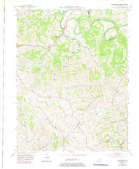
1953 Map of Moorefield
USGS Topo · Published 1978About this map
The Licking River winds along the northern boundary of this Bluegrass region landscape, defining the rugged border where Fleming and Nicholas counties meet. Central to the area is the winding path of Cassidy Creek, which drains much of the central uplands before joining the river. The small settlement of Moorefield serves as a local hub in the south, while Myers occupies a point along the Louisville and Nashville railroad tracks to the west. This mid-century survey reveals a rural society structured around faith and transport, with landmarks like Parrish Chapel, Ishmael Ch, and Locust Grove Ch punctuating the ridges. The landscape is heavily dissected by numerous watercourses, including Somerset Creek and Fishtrap Creek, reflecting the complex topography of the eastern Kentucky hills during the early 1950s.
Find a feature on this map
25 named features on this map. Tap any name to fly to it.
Don’t see what you’re looking for? This feature index may not catch every label — zoom into the map to look around manually.
Map Details
Editions of this 1953 Moorefield Map
2 editions found
Other maps of this area

1952 · Cowan
USGS Topo · 1:24,000

1952 · Owingsville
USGS Topo · 1:24,000

1952 · Sharpsburg
USGS Topo · 1:24,000

1952 · Sherburne
USGS Topo · 1:24,000

1952 · Elizaville
USGS Topo · 1:24,000

1952 · North Middletown
USGS Topo · 1:24,000

1952 · Piqua
USGS Topo · 1:24,000

1953 · Carlisle
USGS Topo · 1:24,000

1953 · Moorefield
USGS Topo · 1:24,000

1956 · Louisville
USGS Topo · 1:250,000