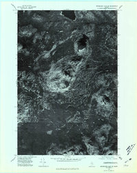
1975 Map of Mooseleuk Lake SE
USGS Topo · Published 1981About this map
Rowe Lake sits at the northern edge of this orthophotoquad, serving as a prominent landmark in a landscape defined by timber and terrain. This 1975 aerial survey captures the dense forest patterns of northern Maine, revealing the network of logging roads and clearings that weave between the region's distinctive peaks. The winding path of Chase Brook cuts through the southern half of the sheet, providing a natural drainage route for the surrounding highlands. The topography is dominated by several named summits, including Round Mountain, Peaked Mountain, Spectacle Mountain, and Center Mountain. Unlike standard topographic maps, this orthophotograph provides a direct visual record of vegetation density and land-use practices in the Maine woods during the mid-1970s, making it an essential resource for understanding the historical footprint of the timber industry in this specific quadrangle.
Find a feature on this map
6 named features on this map. Tap any name to fly to it.
Don’t see what you’re looking for? This feature index may not catch every label — zoom into the map to look around manually.
Map Details
Editions of this 1975 Mooseleuk Lake SE Map
This is the sole edition of this map. No revisions or reprints were ever made.
Other maps of this area

1930 · Greenlaw
USGS Topo · 1:48,000

1931 · Mooseleuk Lake
USGS Topo · 1:48,000

1933 · Greenlaw
USGS Topo · 1:62,500

1935 · Mooseleuk Lake
USGS Topo · 1:62,500

1954 · Millinocket Lake
USGS Topo · 1:62,500

1954 · Grand Lake Seboeis
USGS Topo · 1:62,500

1954 · Presque Isle
USGS Topo · 1:250,000

1958 · Presque Isle
USGS Topo · 1:250,000

1960 · Presque Isle
USGS Topo · 1:250,000
1963 · Mooseleuk Lake
USGS Topo · 1:62,500