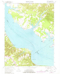
1968 Map of Morattico
USGS Topo · Published 1980About this map
The Rappahannock River dominates this landscape, serving as the primary geographic divider between Richmond, Essex, Lancaster, and Middlesex counties. Along the northern banks, water-oriented settlements like Sharps and Morattico define the coastal character of the Northern Neck, while Bowlers Wharf and Oakley Landing mark historical points of river access. Further inland, the map captures a rural network of crossroads and small communities such as Tidewater, Simons Corner, and Ivondale, often situated near slow-moving water bodies like Myrtle Swamp and Farnham Creek.
Find a feature on this map
43 named features on this map. Tap any name to fly to it.
Don’t see what you’re looking for? This feature index may not catch every label — zoom into the map to look around manually.
Map Details
Editions of this 1968 Morattico Map
2 editions found
Other maps of this area

1917 · Urbanna
USGS Topo · 1:62,500

1917 · Morattico
USGS Topo · 1:62,500

1918 · Tappahannock
USGS Topo · 1:62,500

1918 · Morattico
USGS Topo · 1:62,500

1919 · New Kent
USGS Topo · 1:62,500

1919 · Tappahannock
USGS Topo · 1:62,500

1926 · Morattico
USGS Topo · 1:62,500

1943 · Richmond
USGS Topo · 1:250,000

1944 · Tappahannock
USGS Topo · 1:31,680

1944 · Dunnsville
USGS Topo · 1:31,680