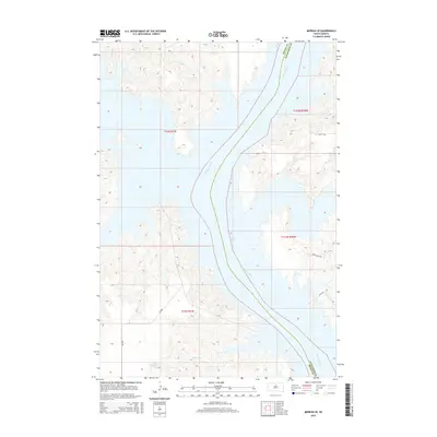
2015 Map of Moreau SE
USGS Topo · Published 2015About this map
Missouri River waters dominate this landscape, flowing through the heart of the region where Dewey and Walworth counties meet. The impoundment of Lake Oahe defines the modern shoreline, flooding the lower reaches of seasonal drainages such as Three Legs Cr and Fielder Cr. This contemporary survey reflects the sprawling reach of the reservoir within the Missouri River trench, a geographical feature that has dictated movement and settlement in north-central South Dakota for generations. Transport across the upland plains is marked by a network of rural routes, including Bia 808 on the western side of the water and traditional section-line roads like Swan Creek Rd and 146th St to the east. The map highlights the intersection of tribal and county jurisdictions amidst a terrain of dissected breaks and wide water.
Find a feature on this map
13 named features on this map. Tap any name to fly to it.
Don’t see what you’re looking for? This feature index may not catch every label — zoom into the map to look around manually.
Map Details
Editions of this 2015 Moreau SE Map
This is the sole edition of this map. No revisions or reprints were ever made.
Other maps of this area

1953 · McIntosh
USGS Topo · 1:250,000

1958 · McIntosh
USGS Topo · 1:250,000

1968 · Moreau NW
USGS Topo · 1:24,000

1968 · Moreau NE
USGS Topo · 1:24,000

1968 · Akaska NW
USGS Topo · 1:24,000

1968 · Akaska SW
USGS Topo · 1:24,000

1968 · Moreau
USGS Topo · 1:24,000

1968 · Moreau SE
USGS Topo · 1:24,000

1969 · Four Bear Creek
USGS Topo · 1:24,000

1970 · Steamboat Creek
USGS Topo · 1:24,000