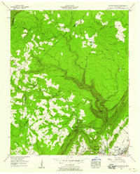
1956 Map of Morgan Springs
USGS Topo · Published 1958About this map
The Cumberland Escarpment dominates this mid-century landscape, where the plateau of Walden Ridge falls sharply toward the Dayton valley. This 1956 survey reveals a dispersed upland community interconnected by local landmarks such as Waldens Ridge Ch and Waldens Ridge Sch. The topography dictates the placement of settlements like Summer City and Morgan Springs on the high ground, while the Tennessee Holiness Campground sits at the base of the ridge. Water management for the valley below is evident at the Dayton Reservoir, fed by the dramatic descent of Henderson Creek and Richland Creek over the cliffs. Genealogy researchers will find several family and community burial grounds, including Frenchs Cem and Swafford Cem, clustered near the base of the escarpment and along the winding Polebridge Road.
Find a feature on this map
64 named features on this map. Tap any name to fly to it.
Don’t see what you’re looking for? This feature index may not catch every label — zoom into the map to look around manually.
Map Details
Editions of this 1956 Morgan Springs Map
This is the sole edition of this map. No revisions or reprints were ever made.
Other maps of this area

1886 · Cleveland
USGS Topo · 1:125,000

1887 · Kingston
USGS Topo · 1:125,000

1888 · Chattanooga
USGS Topo · 1:125,000

1891 · Kingston
USGS Topo · 1:125,000

1892 · Pikeville
USGS Topo · 1:125,000

1892 · Cleveland
USGS Topo · 1:125,000

1893 · Chattanooga
USGS Topo · 1:125,000

1893 · Kingston
USGS Topo · 1:125,000

1895 · Cleveland
USGS Topo · 1:125,000

1895 · Pikeville
USGS Topo · 1:125,000