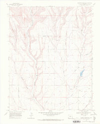
1968 Map of Mormon Reservoir
USGS Topo · Published 1972About this map
The Southern Ute Indian Reservation Boundary bisects this landscape of deep drainages and high mesas, marking a significant transition in land management and historical use. To the north, the terrain is carved by Alkali Gulch and Hay Gulch, where local education and community life centered on the Rockvale School and nearby Hay Gulch Cem. The southern half of the map is defined by the La Plata River valley and its confluence with Cherry Creek, a drainage system flanked by the steep walls of Wildwater Canyon. Water infrastructure is vital to this arid environment, evidenced by the Mormon Reservoir and its Spillway. The presence of a Gas Well and a Pipeline suggests the mid-century industrial development occurring alongside established ranching and agricultural sites like the Kline Cem.
Find a feature on this map
25 named features on this map. Tap any name to fly to it.
Don’t see what you’re looking for? This feature index may not catch every label — zoom into the map to look around manually.
Map Details
Editions of this 1968 Mormon Reservoir Map
This is the sole edition of this map. No revisions or reprints were ever made.
Other maps of this area

1895 · La Plata
USGS Topo · 1:62,500

1897 · La Plata
USGS Topo · 1:62,500

1899 · La Plata
USGS Topo · 1:62,500

1908 · La Plata
USGS Topo · 1:62,500

1912 · Soda Canyon
USGS Topo · 1:62,500

1913 · Red Mesa
USGS Topo · 1:62,500

1915 · Soda Canyon
USGS Topo · 1:62,500

1956 · Cortez
USGS Topo · 1:250,000

1958 · Cortez
USGS Topo · 1:250,000

1959 · Cortez
USGS Topo · 1:250,000