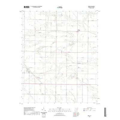
2020 Map of Moro
USGS Topo · Published 2020About this map
Moro serves as the primary hub in this corner of Lee County, where agricultural lands are partitioned by an extensive network of rural roads. The landscape is defined by its low-lying drainage patterns, with Larkin Cr in the north and the meandering Little Hog Tusk Cr in the southwest. Small settlements and crossroads like Oak Forest and Holub Crossing anchor the local community, while several burial grounds, including Mount Moriah Cem and Hawkins Chapel Cem, provide important markers for genealogical research. The map illustrates a strictly organized township and range system, with surveyors' boundaries such as t3n r1e and t2n r2e framing the settlement patterns. The concentration of structures around Moro and the dispersal of farms along routes like Oak Forrest Rd reflect the enduring rural character of this Arkansas Delta region.
Find a feature on this map
58 named features on this map. Tap any name to fly to it.
Don’t see what you’re looking for? This feature index may not catch every label — zoom into the map to look around manually.
Map Details
Editions of this 2020 Moro Map
This is the sole edition of this map. No revisions or reprints were ever made.
Other maps of this area

1940 · Marvell
USGS Topo · 1:62,500

1940 · Holly Grove
USGS Topo · 1:62,500

1940 · Brinkley
USGS Topo · 1:62,500

1940 · Marianna
USGS Topo · 1:62,500

1948 · Helena
USGS Topo · 1:250,000

1950 · Helena
USGS Topo · 1:250,000

1955 · Helena
USGS Topo · 1:250,000

1956 · Marvell
USGS Topo · 1:62,500
1957 · Marianna
USGS Topo · 1:62,500

1957 · Holly Grove
USGS Topo · 1:62,500