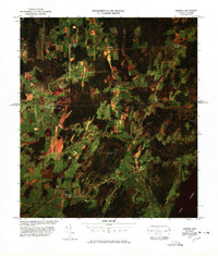
1977 Map of Morses Line Station
USGS Topo · Published 1978About this map
The international border between Vermont and Quebec defines the landscape of this 1970s color image map. Centered on the rural crossing at Morses Line, the map captures the transition from the farm-dotted plains of Franklin to the hills of the Eastern Townships. This orthophoto provides a unique view of the agricultural patterns and woodlots that straddle the line, featuring both the Morses Line Station U S Customs and the Morses Line Canadian Customs facilities.
Find a feature on this map
22 named features on this map. Tap any name to fly to it.
Don’t see what you’re looking for? This feature index may not catch every label — zoom into the map to look around manually.
Map Details
Editions of this 1977 Morses Line Station Map
This is the sole edition of this map. No revisions or reprints were ever made.
Other maps of this area

1914 · St. Albans
USGS Topo · 1:48,000

1916 · St. Albans
USGS Topo · 1:62,500

1920 · Franklin Pond
USGS Topo · 1:62,500

1922 · Enosburg Falls
USGS Topo · 1:48,000

1924 · Enosburg Falls
USGS Topo · 1:62,500

1943 · St. Albans
USGS Topo · 1:62,500

1944 · Enosburg Falls
USGS Topo · 1:62,500

1950 · Lake Champlain
USGS Topo · 1:250,000
1953 · Enosburg Falls
USGS Topo · 1:62,500

1958 · Lake Champlain
USGS Topo · 1:250,000