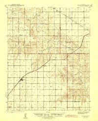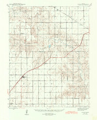
1944 Map of Moscow
USGS Topo · Published 1944About this map
The Atchison Topeka and Santa Fe railroad serves as the primary industrial artery through the Kansas high plains, connecting the settlement of Moscow to the wider region. This mid-century landscape is defined by its rural education network, featuring numerous country schoolhouses like Hillside Sch, Cimarron Grange Sch, and Vanceville Sch that served the surrounding farmsteads. The drainage of the Cimarron River and its North Fork carve through the townships of Sullivan, Dudley, and Liberal, revealing the topographic texture of the river valley. Genealogists may find value in the specific placement of these rural landmarks, including the Ramsey Sch (abandoned) and Ethelton Sch, which provide a clear picture of the community structure in Stevens and Haskell counties before the consolidation of rural school districts.
Find a feature on this map
21 named features on this map. Tap any name to fly to it.
Don’t see what you’re looking for? This feature index may not catch every label — zoom into the map to look around manually.
Map Details
Editions of this 1944 Moscow Map
This is the sole edition of this map. No revisions or reprints were ever made.
Historical Maps of Moscow Through Time
8 maps found