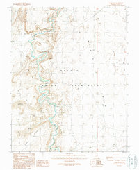
1989 Map of Moses Rock
USGS Topo · Published 1989About this map
Poncho House Cliff Dwellings and other Cliff Dwellings anchor the high canyon walls in this corner of the Navajo Indian Reservation. The landscape is dominated by the winding course of Chinle Creek, which carves through the sandstone with numerous rapids and falls noted along its path. To the east, the flat expanse of Nokaito Bench contrasts sharply with the western terrain of Garnet Ridge and the sand dunes that collect near the water. Archeological interest is high here, as the map documents specific ancient sites and names like Hoosteen Tso Canyon and the monolith Moses Rock. Modern activity is sparse, indicated only by scattered 4wd tracks and occasional drill holes, emphasizing the preservation of the area's ancestral architecture and natural landforms.
Find a feature on this map
18 named features on this map. Tap any name to fly to it.
Don’t see what you’re looking for? This feature index may not catch every label — zoom into the map to look around manually.
Map Details
Editions of this 1989 Moses Rock Map
This is the sole edition of this map. No revisions or reprints were ever made.
Other maps of this area

1886 · Abajo
USGS Topo · 1:250,000

1892 · Abajo
USGS Topo · 1:250,000

1892 · Canyon De Chelly
USGS Topo · 1:250,000

1893 · Abajo
USGS Topo · 1:250,000

1952 · Bluff 3 SE
USGS Topo · 1:24,000

1952 · Dinnehotso
USGS Topo · 1:62,500

1952 · Setsiltso Springs 2 NE
USGS Topo · 1:24,000

1954 · Shiprock
USGS Topo · 1:250,000

1956 · Cortez
USGS Topo · 1:250,000

1958 · Cortez
USGS Topo · 1:250,000