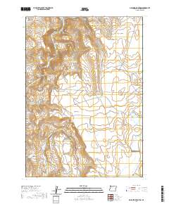
2020 Map of Mosquito Mountain
USGS Topo · Published 2020About this map
Malheur River flows through the northern reaches of this high-desert landscape in Malheur County, where water management is the primary driver of settlement patterns. The tiny community of Creston anchors the southeast corner, connected to the wider region by the winding Granite Creek Rd. The terrain is defined by a series of deep drainages such as Big Mosquito Canyon and Slaughter Gulch, which feed a sophisticated network of small-scale irrigation and livestock watering points. Numerous man-made features like Lower Slaughter Gulch Reservoir, Parks Reservoir, and Easterday Ditch reveal how ranchers have historically harnessed the intermittent flow from the heights of Mosquito Mtn. Land use is further characterized by large open tracts like Mosquito Flat and Barber Flat, alongside the industrial presence of the Westfield Pit.
Find a feature on this map
35 named features on this map. Tap any name to fly to it.
Don’t see what you’re looking for? This feature index may not catch every label — zoom into the map to look around manually.
Map Details
Editions of this 2020 Mosquito Mountain Map
This is the sole edition of this map. No revisions or reprints were ever made.
Other maps of this area

1955 · Burns
USGS Topo · 1:250,000

1955 · Boise
USGS Topo · 1:250,000

1958 · Burns
USGS Topo · 1:250,000

1958 · Boise
USGS Topo · 1:250,000

1959 · Burns
USGS Topo · 1:250,000

1962 · Boise
USGS Topo · 1:250,000

1972 · Shumway Reservoir
USGS Topo · 1:24,000
1972 · Star Creek Reservoir
USGS Topo · 1:24,000
1972 · Mc Ewen Butte
USGS Topo · 1:24,000
1972 · Monument Peak
USGS Topo · 1:24,000