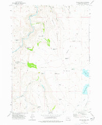
1973 Map of Mosquito Mtn
USGS Topo · Published 1977About this map
The Malheur River cuts through the high desert of Malheur County, accompanied by the Union Pacific rail line following its winding course. This semi-arid landscape is defined by its water management systems, including numerous small reservoirs and wells like Levanger Well and Parks Reservoir. These features, along with names like Barber Flat and Mosquito Flat, reflect a landscape adapted for livestock and resource extraction. Evidence of local industry is seen at Westfield Pit, while the presence of the Landing Strip near the small settlement of Creston suggests the importance of aerial access in this isolated territory.
Find a feature on this map
38 named features on this map. Tap any name to fly to it.
Don’t see what you’re looking for? This feature index may not catch every label — zoom into the map to look around manually.
Map Details
Editions of this 1973 Mosquito Mtn Map
This is the sole edition of this map. No revisions or reprints were ever made.
Other maps of this area

1955 · Burns
USGS Topo · 1:250,000

1955 · Boise
USGS Topo · 1:250,000

1958 · Burns
USGS Topo · 1:250,000

1958 · Boise
USGS Topo · 1:250,000

1959 · Burns
USGS Topo · 1:250,000

1962 · Boise
USGS Topo · 1:250,000

1972 · Shumway Reservoir
USGS Topo · 1:24,000
1972 · Star Creek Reservoir
USGS Topo · 1:24,000
1972 · Mc Ewen Butte
USGS Topo · 1:24,000
1972 · Monument Peak
USGS Topo · 1:24,000