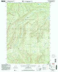
2004 Map of Mosquito Peak
USGS Topo · Published 2007About this map
Mosquito Peak and Dead Mule Peak anchor the southern reaches of this high-altitude landscape, part of the extensive Frank Church River of No Return Wilderness. The map reveals a complex drainage system within the Payette National Forest, where the South Fork Chamberlain Creek and Chamberlain Creek converge near the wide expanse of the Chamberlain Basin. Evidence of early backcountry infrastructure is visible at Cow Corrals and the Fourway Junction, likely serving as significant waypoints for forest management or seasonal grazing.
Find a feature on this map
24 named features on this map. Tap any name to fly to it.
Don’t see what you’re looking for? This feature index may not catch every label — zoom into the map to look around manually.
Map Details
Editions of this 2004 Mosquito Peak Map
This is the sole edition of this map. No revisions or reprints were ever made.
Other maps of this area

1937 · Big Creek
USGS Topo · 1:48,000

1942 · Big Creek
USGS Topo · 1:62,500

1956 · Elk City
USGS Topo · 1:250,000

1960 · Elk City
USGS Topo · 1:250,000

1969 · Wolf Fang Peak
USGS Topo · 1:24,000

1969 · Big Creek
USGS Topo · 1:24,000

1973 · Bismark Mtn
USGS Topo · 1:24,000

1974 · Meadow Of Doubt
USGS Topo · 1:24,000

1978 · Mosquito Peak
USGS Topo · 1:24,000

1978 · Chicken Peak
USGS Topo · 1:24,000