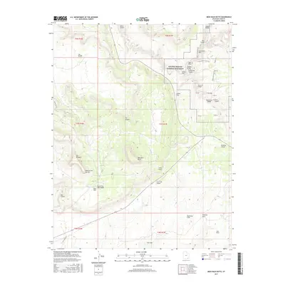
2017 Map of Moss Back Butte
USGS Topo · Published 2017About this map
Natural Bridges National Monument anchors the northeastern corner of this San Juan County landscape, showcasing massive geological spans including Sipapu Bridge, Kachina Bridge, and Owachomo Bridge. The terrain is defined by deep incisions like Armstrong Canyon and White Canyon, which drain the surrounding mesas and buttes. To the south, the prominent Moss Back Butte and Moss Back ridges overlook the North Fork Red Canyon and the sweeping Red House Cliffs. Notable local landmarks such as Atomic Rock, Cathedral Rock, and Ruin Rock provide orientation points across the high desert. The inclusion of Radium King Rd and Gulch Creek Rd indicates the sparse but critical transportation network connecting remote outposts like Fry Canyon to the larger region. This survey captures a classic Colorado Plateau vista of canyons, gulches, and flat-topped tables like the Tables of the Sun Hills.
Find a feature on this map
47 named features on this map. Tap any name to fly to it.
Don’t see what you’re looking for? This feature index may not catch every label — zoom into the map to look around manually.
Map Details
Editions of this 2017 Moss Back Butte Map
This is the sole edition of this map. No revisions or reprints were ever made.
Other maps of this area

1886 · Henry Mountains
USGS Topo · 1:250,000

1886 · Abajo
USGS Topo · 1:250,000

1892 · Abajo
USGS Topo · 1:250,000

1892 · Henry Mountains
USGS Topo · 1:250,000

1893 · Abajo
USGS Topo · 1:250,000

1935 · Elk Ridge
USGS Topo · 1:96,000

1940 · Elk Ridge
USGS Topo · 1:125,000

1952 · Natural Bridges
USGS Topo · 1:62,500

1954 · White Canyon 4 NE
USGS Topo · 1:24,000

1954 · White Canyon 4 SE
USGS Topo · 1:24,000