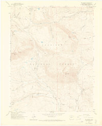
1961 Map of Mount Axtell
USGS Topo · Published 1969About this map
High-altitude mining and timber operations define the topography of the Gunnison National Forest as it appeared in the early 1960s. The landscape is marked by the remnants of the silver and coal booms, including the Ruby (Site) and the Old Railroad Grade that once connected these remote camps. To the south, Baldwin serves as a focal point near active extractions like the Baldwin Mine and Kubler Mine, while the northern reaches near Kebler Pass show a complex network of pack trails and jeep tracks leading to the Keystone Mine and its associated Tailings Ponds. The presence of the Irwin Cem and former settlements like Floresta provides vital clues for genealogists tracking the families who worked the Anthracite Range. The map effectively captures the transition from industrial extraction to the managed wilderness of the mid-century forest service era.
Find a feature on this map
43 named features on this map. Tap any name to fly to it.
Don’t see what you’re looking for? This feature index may not catch every label — zoom into the map to look around manually.
Map Details
Editions of this 1961 Mount Axtell Map
4 editions found

Other maps of this area

1888 · Crested Butte
USGS Topo · 1:62,500

1888 · Anthracite
USGS Topo · 1:62,500

1889 · Crested Butte
USGS Topo · 1:62,500

1889 · Anthracite
USGS Topo · 1:62,500

1893 · Anthracite
USGS Topo · 1:62,500

1893 · Crested Butte
USGS Topo · 1:62,500

1894 · Anthracite
USGS Topo · 1:62,500

1956 · Montrose
USGS Topo · 1:250,000

1959 · Montrose
USGS Topo · 1:250,000

1960 · Montrose
USGS Topo · 1:250,000